The amount of information about the streets in the area varies from great detail (the Gray streets) to the almost non-existent (particularly Minto Street). This is the result of the compilers working gently outward from their own streets. It is hoped that coverage will be transformed as more people become involved or merely add information from their own research into the buildings they know best. Contributions are welcomed, indeed sought...
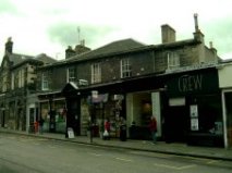
The street is named after Admiral Adam Duncan, victor over a Dutch Fleet in 1797 at the Battle of Camperdown. Duncan was a friend and patient of Dr Benjamin Bell of Newington House. This was not the only part of Edinburgh to commemorate Admiral Duncan's triumph and the same name was given to a street, north of Drummond Place, in the New Town.
In 1882 the City Council, as part of wider efforts to correct duplications in street naming, proposed that Duncan Street (Newington) be renamed Croall Street. The Newington residents bitterly fought the proposal. Eventually, in 1885, the matter was resolved with Newington retaining its Duncan Street and the New Town street being renamed Dundonald Street (commemorating another noted naval commander).
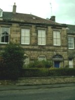
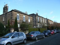
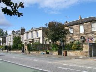
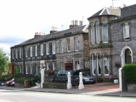
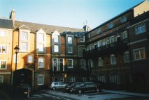
Kirkwood's map of 1817 shows no space for building in this section as terraces planned for Upper Gray Street and Minto Street would have reached almost to Duncan Street. By 1826 this situation had been reversed and Leslie's map shows that a start had been made to a terrace on Duncan Street. What are now numbers 1, 2, 3, 4 and 5 predate the 1826 map and numbers 6, 7, 8 and 9 were occupied some years later.
Leslie's map suggests a symmetric terrace of 12 houses with more prominent pairs at the centre and at each end. At the east end only a single flatted house was built with its upper level accessed from Minto Street. Perhaps Mr Alison, the developer/builder of the terrace, intended a similar arrangement to complete the west end, but this was never built.
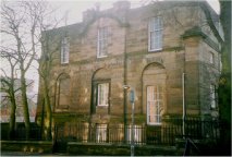
Number 5 (now Edinburgh Unionist Club) became a girls' day school from 1855 to 1891 and was later to serve as a dancing academy and then as a masonic lodge.
Part of this section falls within the West Blacket area and contains the BT building and Duncan Street Baptist Church with its associated hall. (See the Upper Gray Street section of this page for notes on the BT building.)
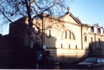
The classically fronted church opened c1841 to house a new Baptist congregation. Its capacity (750 seats) exceeded demand however and the church was soon sold to the United Presbyterian Church. This new congregation flourished, outgrew the Duncan Street church, and moved north in 1863 to a new church, still standing (now as a lighting showroom) on the corner of Grange Road and Causewayside. Duncan Street Church was sold back to the Baptist Church. During the later 1800s the hall to the rear housed day and evening schools and was a venue for public meetings.
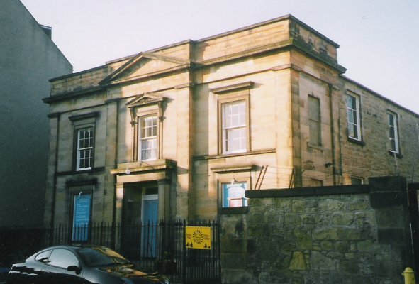
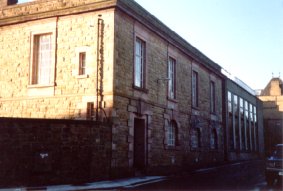
Until c1910 this site was occupied by a single house with extensive grounds. In 1911, John George Bartholemew (of the 4th generation of Bartholemew cartographers) moved from a site by Holyrood Park to his new purpose-built 'Edinburgh Geographical Institute' in Duncan Street. The centre portion of the frontage came from Falcon Hall, the former Bartholemew home in Morningside.
A further two generations of Bartholemew were to continue and develop the business until 1985 when it was taken over by Harper Collins. Their Duncan Street operation closed in 1995 with the Institute building being converted to flats. The name - 'Bartholemew House', and a commemorative plaque remind us of the building's historic connections.
Of these buildings only the present day Dental Clinic lies within the West Blacket Area. Previously Duncan Street Special School; its Duncan Street and South Gray Street facades still show evidence of the three early 19th century houses which were combined to form the school around 1910. (See the South Gray Street section of this page for further information.)
The street name derives from the parish of Middlebie in Dumfriesshire where the Bell family originated.
In its early days, as now, Middleby Street was totally residential but street directories show a more varied pattern of use. A number of houses operated for periods as schools or commercial premises.
Early development can be seen on Kirkwood's map (1817) and seven houses 1, 3, ... 13 were built by the late 1820s.
Post Office Directory entries for numbers 11 and 13 cease in the 1920s and they were demolished c1937 for an extension to the printing works of cartographers, John Bartholemew & Son Ltd. Number 11 seems to have been similar in size and style to number 9 but number 13 was a single storey house standing further back from the street than its neighbours. The present flats replaced the printing works in the 1990s.
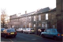
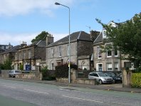
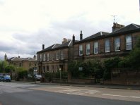
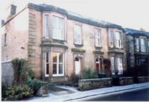
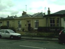
This side of the street, with six houses, numbers 2, 4, .. 12 in three linked pairs, dates from c1827. Good use has been made of the southward sloping site, allowing an elegant single-storey, classically detailed frontage at street level with a 'basement' storey giving access to the rear gardens. For about 30 years from c1900, number 12 operated as a laundry.
Much research remains to be done on Minto Street's buildings and their occupants. These notes are based primarily on a study of maps (comparing them with each other and with what can be seen on the ground today) and of Post Office directories (from 1883/84 to 1953/54 at 10 year intervals). Hopefully future studies involving Census Returns, further Post Office Directories, old newspapers and other sources will fill some of the gaps in our knowledge.
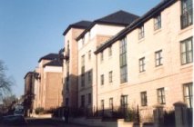
The picture so far is of a street that has maintained its basic structure for close on two centuries. Virtually all of its 50+ houses were occupied by the mid 1830s. Only one original house, 52, has been lost and the only significant 'new builds' are the RBS branch that replaced it (c1903) and the row of shops (1870s) close to the West Mayfield corner.
All houses in this stretch (numbers 1, 2 ... 13) predate Leslie's 1826 map. Numbers 3, 4, 5 and 6 seem the oldest, appearing also on Kirkwood's map of 1816/17.
The Edinburgh & Leith PO Directory of 1833/34 (the earliest to include a street index) lists occupants for all 13 properties, notably James Spittal, Lord Provost 1833-37, at 3 Minto Street. Most of the 1833/34 occupants match the names on Leslie's map.
In the mid 1870's the northerly houses came under pressure for development to shops. ('The Scotsman' of 17th July 1875 advertises 1 Minto Street for sale, stating that 'The Property is adapted for alteration into Shops, for which there is a large demand locally'.) This change to commercial use did not take place, but soon afterwards shops were to appear in the front gardens of neighbouring Arniston Place.
Numbers 14, 15 and 18 are the oldest houses (pre 1817) and are shown on Kirkwood's map. By the time of Leslie's map (1826) all numbers up to 21 are in place. 22, 24, 25 and 26 were occupied by 1833/34 and the remaining houses 23, 23a, and 27 ... 30 probably followed soon after. They certainly all appear on the 1849-53 OS Town Plan.
On Leslie's map, numbers 16, 17, 18, 19 and 20 all carry the name 'Mr Macgregor', probably explaining their consistency in architectural detail. (16, 17 and 18 now form the Minto Hotel.) Number 18 housed a boys' school (Clarehall Academy) from 1869 until the late 1890s. Soon after it operated as Medical Baths offering its clients a wide choice of 'medical, Nauheim, electric & hot air baths'. 18 is listed in PO Directories as 'Minto Private Hotel' from the early 1930s.
The long back gardens of Middleby Street result in this stretch of Minto Street containing fewer houses than the other quarters.
No building here appears on Kirkwood's map and only 31, 32, 33 and 34 are shown by Leslie (1826). The other group of houses, 35, 36, 37 and 38, were certainly occupied by the mid 1830s.
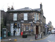
Number 34 became a branch of Bank of Scotland around 1890, remaining as such for over 100 years. For much of that period the agent/manager probably lived 'above the shop'. 34 was converted back to purely residential use early this century.
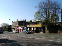
The row of shops between 31 and 32 dates from the early 1870s and has served a wide range of community needs. In its early days, as well as a baker and a grocer, the row contained a painter, a builder and a plumber. 'Servant Wanted' advertisements in 'The Scotsman' frequently requested applicants to contact one or other of the shops rather than making direct contact with the potential employer.
Possibly as the building of neighbouring suburbs declined the construction trades moved elsewhere and pharmacists, newsagents and a Post Office took over. In the 1880s J D Richardson (butcher and poulterer) took one of the shops, soon moving to the prominent site on the corner with West Mayfied where the business continued for about a century.
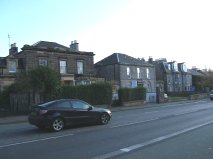
While Kirkwood's map suggests that a long terrace was once planned for this section, Leslie's map (some 10 years later) shows a much shorter terrace 40, 41, 42 and 43 and the detached or semi-detached houses 44, 45 ... 52 all but the last of which we see today. Number 39 at the end of the Duncan Street terrace is of a roughly similar date.
The 1905 OS map (available in National Library of Scotland's Causewayside Map Room, but not in their online collection) shows number 51 as a bank. Around 1903 the bank (then a branch of Commercial Bank of Scotland) seems to have moved next door to newly built premises on the corner with Salisbury Place, replacing the original 52 Minto Street.
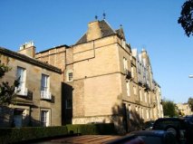
While this side of Salisbury Place does not lie within West Blacket its dominant building, Longmore House, is such an important feature of our streetscape that it can not go unmentioned.
The main part of this building opened in 1880 as 'The Longmore Hospital for Incurables', funded from the estate of John Alexander Longmore of Deanhaugh whose grandfather, Adam Longmore, had been an early resident of nearby Salisbury Road. The hospital replaced a number of early houses with front gardens to the street and over time it expanded its building and grounds to cover nearly all of the street's length.
Over time the 'Hospital for Incurables' changed to more general medical use, before closing around 1990. In 1994 it reopened as 'Longmore House', the headquarters of Historic Scotland.
For many years this section of street was dominated by the factory of biscuit makers, Robert Middlemass & Son Ltd. In 1869 the founder, Robert Middlemass moved premises to a new factory on Causewayside, close to the corner with Salisbury Place. Ordnance Survey town plans let us track the factory's eventual growth eastwards to Upper Gray Street and northwards to Salibury Place.
The Middlemass business closed in 1974 and part of the factory became a temporary home for the National Library of Scotland's Map Collection. In the 1980s the buildings were demolished to make way for the Library's current Causewayside premises.
Two of Salisbury Place's early 19th century houses can still be seen in this section of the street: what are now number 21 (on the Upper Gray Street corner) and number 7 (hidden behind the row of shop frontages). A further early house, towards the Minto Street corner, was replaced c1910 by the current bank building. These houses originally stood further back from the street with substantial gardens. The street was widened to cope with increasing traffic around 1890 and the row of shops dates from that time.
Post Office Directories list the occupants and trades of the shops. Until recent times tailors and outfitters predominated; but grocers, fruiterers, plumbers, a cabinetmaker, a cycle agent and a coal and coke merchant have all served the neighbourhood. 9 Salisbury Place (with several changes of proprietor and doubtless many changes in fashion) may have been a hairdresser's since its opening in the 1890s. Number 17 has contained 'Grange Road Post Office' since the early 1930s.
Starting with the 1876-77 survey, Ordinance Survey plans show a yard and cluster of small buildings to the east of number 21. Until c1937 these were studios for two prominent photographers (see our 'Notable People' page). Following other commercial uses, two relatively modern houses 19 and 19a now occupy the site.
This side of South Gray Street contains some of West Blacket's oldest houses. Kirkwood's map of 1817 shows eight substantial buildings already occupied on that side. One other (number 7) appears on Leslie's 1826 map. While numbers 4 to 9 retain almost all of their early 19th century outward appearance, sites 1 to 3 are now greatly changed.
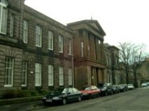
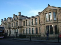
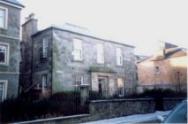
Between 1905 and 1907 Edinburgh School Board acquired number 1 (Holland Lodge) and two neighbouring Georgian villas in Duncan Street to provide 'a school for defective children'. J A Carfrae, the board's architect, planned the conversion. By autumn 1911 the school was in use providing both for 'mentally defective children' and for 'cripple and invalid children' in 7 classes of about 20 children.
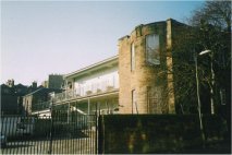
Duncan Street Special School represented advanced thinking for its time. All classrooms connected directly to south facing verandas by folding glass doors and whenever possible classes were taught in the open air. Gardens to the south were another important feature, giving the pupils an attractive outlook and space in which to play. The building (now a dental clinic) retains the verandas but the gardens have given way to car park. The South Gray St elevation and the short, curved portion of wall, towards the south-east corner still show evidence of the former Holland Lodge.
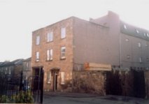
The original house at 2 South Gray Street stood until c1940, its site now providing a storage yard and access for the timber supplier on neighbouring Ratcliffe Terrace.
3 South Gray Street gave way to commercial pressures considerably earlier, in the late 1890s. The 1901-02 Post Office Directory lists the rebuilt site as factory for Cranston & Elliot 'silk mercers, general drapers, house furnishers, cabinetmakers, upholsterers, house agents, removal contractors, 33, 34 .. 38 Princes Street'. The firm was headed by Sir Thomas Cranston, Lord Provost about that time, and had previously occupied the site of the Balmoral Hotel. In the 1980s the former factory reverted to residential use as Middleby Court.
In the very early 1900s, first number 4 and then number 5 were occupied by Adam Currie, founder of a substantial joinery business. Early in his career he seems to have conducted business from his back garden(s), now in use by the builders, Scott & Brown.
The substantial mansion, now divided, on South Gray Street's corner with West Mayfield (and with addresses on each street) was originally a single house (9 South Gray Street). In the 1850s and 1860s it was a school for girls, operated by the Mouat sisters. As well as the 4 Misses Mouat and 4 servants, the 1861 census records 20 boarders aged from 6 to 19. The school must have flourished, later moving to Grange House, the ancient mansion of the Grange estate.
The south end of the east side of the street contains two pairs of semi-detached villas, both more recent than the houses opposite. The northern pair, dating from c1830, was originally numbered 10 and 11 and became 12 and 13 on completion of the southern pair (the present 10 and 11) c1872.
The flats to the north of Middleby Street were built in the 1990s replacing the printing works of cartographers, John Bartholemew & Son Ltd.
If researching Upper Gray Street's history you need to be aware that 19th century house numbers do not correspond with what we see today.
Prior to the 1890s, Upper Gray Street numbers started at 1 at the north east corner, increased southwards down the east side, then northwards up the west side.
Around 1841, house numbers greater than 9 were renumbered to accommodate recent and planned building, mainly on the east side. (The 1841 census fell in the middle of this operation and some numbers appear twice, applied to different households.)
By the 1880s there had been further new building, particularly on the west side, and there was a further renumbering (largely surviving today) with odd numbers on the east and even numbers on the west.
Numbers 1, 3, 5 and 11 are among the street's earliest buildings,appearing on Kirkwood's map (1817). The end building was always flatted with the upper levels accessed, as now, from Salisbury Place and with the lower flat on Upper Gray Street. The earliest title deeds of number 3 are dated 4th November 1812.
In 1889 the original house at number 7 made way for St Columba's Roman Catholic Church and soon afterwards number 9 became home to its clergy. The present Church House at number 9 dates from 1938. The Church Halls, further down the street (dating from 1928) replaced another of the street's early buildings, which contained 2 houses, 13 and 15. Number 11 (sandwiched between Church House and Halls) retains its original form.
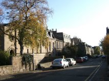
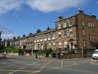
The long terrace to the south of the church halls may look uniform at first glance, but closer examination shows differences in architecture along its length. It was completed in three stages over some 35 years: numbers 39, 37, 35, 33 and 31 - c1825, numbers 29, 27, 25 and 23 - c1840, and numbers 21 and 19 - c1861. It comprises five symmetric pairs of doors and windows with changes in detail between the phases of construction. The end house (37/39) was always flatted.
On Leslie's map (1826), the name 'Mr Alison' is associated with the terrace and with many of the surrounding properties, either planned or recently built. He and his sons may have been the builders of much of the Upper Gray Street and Duncan Street terraces and of the north side of Middleby street. The 1841 census shows the Alison sons and their then-widowed mother living at number 39.
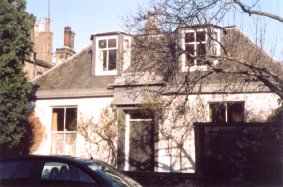
South of the terrace is number 41 (Devon cottage), dating from c1840. The cottage, together with the mixture of yards, sheds and workshops beyond, seems to have developed on the site originally intended for the westward extension of the incomplete Duncan Street terrace.
Early maps show little building on the street's west side. In Leslie's map (1826) this triangular area is split into 5 plots, increasing in depth from north to south. The non-rectangular plan may explain why this side never developed into a terrace or into a row of villas as in other parts of West Blacket.
No trace remains of the original buildings towards the north west corner where some shops may once have stood. Between the 1870s and early 1900s Middlemass's biscuit factory on Causewayside extended first eastwards and then northwards to occupy almost all of the site. A flatted villa, latterly 4/6 Upper Gray Street, did survive until the construction of the National Library of Scotland building on the Middlemas site in the 1980s.
The two pairs of villas, numbers 12/14 and 16/18, date from the 1860s taking the place of earlier commercial premises such as a dairy and laundry. Until renumbering in the 1880s all four carried the number 28. This confusing situation may be why they were soon named respectively, Victoria/Albert and Seymour/Jane. These names still appear on their frontages and the old number 28 can be read on number 14.
One large villa from the area's earliest days still stands as number 22. The threatened demolition of this villa for office development in the 1960s, by builders Peter Walker, led to the formation of the Upper Gray Street Residents' Association, a forerunner of the West Blacket Association. The villa was saved and after use as an office by Peter Walkers reverted to residential use in the 1990s.
The original use of the site to the south of number 22 is unclear, but it seems to have been occupied up to c1880 by commercial premises and some small dwellings. J.W. & G.S. Stratton (road contractors and quarry masters) then developed it, partly as stables and yard for their road-building business, and partly, through the upper levels of the tenement block, as a property investment of 16 (mainly 3 roomed) flats. The Strattons' family home was then 13 Middleby Street and the building's architect, Robert Morham (the City Architect), was living in Upper Gray Street close to that time.
On George Stratton's death in 1897 the road-building part of the business ceased and the site was leased to the 'Edinburgh Street Tramways Company'. Despite its name, this company no longer operated trams in Edinburgh but did operate a smaller network in Leith and Portobello. Their rental of the site was probably an attempt to grow the horse-bus part of their business to serve the growing southern suburbs on the periphery of the cable-tram network then operated by 'Edinburgh and Districts Tramways Company'. In 1903 Leith Council offered 'Edinburgh Street Tramways Company' Ł60000 for their remaining tram interests. Conditions of the offer were that they should give up bus operations, wind up their affairs and 'cease to exist'. In 1905 Upper Gray Street was the location for sales comprising horses, omnibuses, harness and even drivers' overcoats and conductors' bags.
The next tenant, Henry L Sawers, by 1907 was advertising as sole agent for American built Winton Motor Cars and as providing garaging for private cars. 1909 Scotsman advertisements highlighted 'motor repairs' and 'expert work on Daimler, Panhard and Humber'. Sawers died in 1915 and the site continued as the base for various transport and building businesses. In the 1990s the tenement block was converted and extended as housing by Applecross Ltd, preserving the front stonework and rear brickwork of Morham's original building.
The villas to the south of the tenement, numbers 36/38 and 40/42, do not appear on early maps but may date from c1838. They were certainly occupied by the 1841 census. Between 1912 and 1948 number 36 was the 'Livingstone Hall Home for Friendless Girls'. The Scotsman of 6th June 1912 reported its opening at which one speaker said 'the all-important object of the Home was to assist girls who were absolutely friendless, or who had been for the first time in the Police Court'. The Scotsman reported many Annual Meetings of the Home, providing insights into its work, including the extra strains brought on by war-time social conditions.
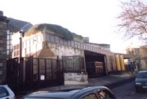
Finally, on the east corner of Upper Gray Street and Duncan Street, is a 1923 telephone exchange with a 1950s extension to the north. In the early hours of Sunday 3rd October 1926 this became one of 4 exchanges comprising Edinburgh's new Automatic Telephone System, allowing subscribers for the first time to make local calls without the intervention of an operator. The building is still in use by BT. Prior to the telephone exchange, the site contained a dwelling house (adjacent to number 42) and business premises (towards Duncan Street). From c1850 to c1914 house and yard were occupied by carpenters/joiners named first Alison and later McTurk, descendants of the 'Mr Alison' whose name is found on the early (1817/26) maps of the area.
West Mayfield follows part of the route of an ancient east/west road across the Burgh Muir from the old Dalkeith Road to what is now Morningside. Prior to c1872 the name Mayfield Loan applied to both East and West Mayfield.
Leslie's 1826 map shows Mayfield Loan forming the southern boundary of the Lands of Newington and Belleville. By that time a start had been made to building at the east end of West Mayfield's terrace. Soon afterwards the full length of Hamilton Place (as the terrace was then known) was complete.
To the west of 9 South Gray Street stood another substantial old house, named Mayfield Cottage on the 1849-53 OS Town Plan. This cottage, together with other buildings towards Causewayside, made way for Cochrane's Garage in the 1930s. The garage in turn was replaced by the present flats around 2000.
The earliest occupants of West Mayfield would have enjoyed uninterrupted views over open land to the south. However by the time of the 1876-77 OS Town Plan there were houses opposite and the city was expanding rapidly southwards. The church on the south west corner, now Mayfield Salisbury Church, was built soon after that OS Survey.