For links to the maps referred to below, go to the 'Key Maps' section on this website.
Newington, stretching (in terms of current street names) from East and West Preston Street in the north to East and West Mayfield in the south and lying between Causewayside to the west and Dalkeith Road to the east, was once part of the city's Burgh Muir. It was one of the areas of the Muir feud out by the Town Council in 1586 and remained largely as open countryside for more than 2 centuries. Causewayside and Dalkeith Road however, formed parts of important toll roads into the city from the south and Causewayside and Sciennes became significant communities.
In the later 1700s growing congestion within the Old Town was alleviated, principally by expansion of the New Town to its north. However, completion of South Bridge in 1788 was to pave the way for southerly development.
West Blacket's street plan and many of its houses date from the first quarter of the nineteenth century when much of the Newington area was being developed as an early southern suburb to the growing city.
The area therefore dates from the same period as some of the New Town developments to the north and north-west of Queen Street. Public works of the period included construction of the Royal Institution (now Royal Scottish Academy) and a new Royal High School. Register House and Edinburgh University's Old College were also completed around this time.
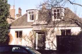
In 1805 Dr Benjamin Bell, an astute businessman as well as one of the most notable surgeons of his day, acquired the lands of Newington and set about building Newington House, towards the south-east corner of the district. Bell died there in 1806, before completion of his house, but not before initiating the area's development.
His project was continued by his son George, another surgeon, who
proceeded with the feuing of all but the south-east corner of the district,
around Newington House, which was now the property of Sir George Stewart
of Grandtully.
Kirkwood's map (1817) shows a new, broad street, Minto Street, as the central north/south artery of the new district. Substantial building had already taken place on its east side, in Salisbury Road (and Place) and in parts of Gray Street and Middleby Street. The map also shows 'Intended Improvements' for the west side of Minto Street and for the south east end of Upper Gray Street which were significantly different from what was actually built just a few years later. In 1817, this developing area was relatively remote from the rest of the city. As well as open countryside to east, south and west, Kirkwood's map shows substantial open space to the north.
From 1825, feus were offered in the area closer to Newington House. Leslie's map (1826) is contemporary with this feuing. Lodge houses, guarding gateways on Minto Street and Dalkeith Road, were built, securing the seclusion of the Blacket area. Meanwhile West Blacket had experienced further residential growth. Houses had been built on the west side of Minto Street and the north of Middleby Street. A start had been made to the terraces in Upper Gray Street, Duncan Street and West Mayfield.
Mid 19th century housing development in West Blacket was more sporadic, due probably to the ups and downs of trade cycles. The western end of the Duncan Street terrace was never completed and this site and a number of other 'gap sites' became home to various small businesses. The Upper Gray Street terrace was not completed until the early 1860s. In the 60s and early 70s further pairs of villas were added to the area, two to Upper Gray Street and one to South Gray Street.
Until this time virtually all of West Blacket's houses were substantial in size and were typically occupied by professionals, business proprietors and people of independent means. Most houses had at least one 'live in' servant, often a young girl from rural Scotland.
While most of Newington (particularly Blacket) was to preserve its quality residential character throughout the 19th century and beyond, neighbouring Causewayside became progressively more industrialised. The 1877 OS map shows 3 printing and publishing works, a laundry, a biscuit manufactury and a 'horse bazaar' occupying sites, bordering on West Blacket, which on the 1853 OS map had been shown as substantial properties and gardens. Increasingly there was development pressure on West Blacket's 'gap-sites' and even on some of its original buildings to accommodate industry and tenement housing.
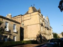
Around 1880, one gap in Upper Gray Street was secured by the Stratton family as a base for their road-construction business. They built the tall L- shaped tenement building that still dominates the west side of the street. The business occupied the lower levels and the surrounding yard. Above were 15 or so small flats, occupied generally by craftsmen, semi-skilled workers and domestic servants.
While the flats in the tenement (generally of 3 rooms) were cramped in relation to the spacious houses elsewhere in the area, they were substantially better than many of those in neighbouring Causewayside where by that time conditions had degenerated to the extent that it contained some of the worst slums in Edinburgh.
The South Side Story (John G Gray) contains vivid extracts from the writings of a Minister and two Missionaries working in those slums. Two accounts refer to Newington Buildings (the 'Brickie') that stood to the rear of the Stratton's tenement. In the 'Brickie' were 80 single-apartment houses, accommodating 'a population as large as any one of 50 parishes in Scotland'.
From the 1850s West Blacket and surrounding areas were served by public transport, first by horse-drawn bus and from 1871 by horse-drawn tram. The 1877 OS Town Plan shows tram-lines on Minto Street, providing a north/south connection, and lines on Salisbury Place leading westwards towards Morningside. In 1884 the South Suburban Railway was opened, passing a short distance to the south.
The late 19th and early 20th centuries saw the loss of some of West Blacket's original buildings.
In 1889 St Columba's Roman Catholic Church replaced one of Upper Gray Street's earliest houses and a few years later, 3 South Gray Street gave way to workshops for Cranston & Elliot, cabinet makers and upholsterers.
Around 1910, 1 South Gray Street and two adjoining houses in Duncan Street were combined and converted to form Duncan Street Special School.
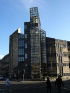
From 1911 the Edinburgh Geographic Institute of renowned cartographers John Bartholemew & Son Ltd replaced an early house on Duncan Street with its factory eventually extending over part of Middleby Street.
Among other commercial developments were a succession of expansions of the Middlemass biscuit factory from Causewayside on to Salisbury Place and Upper Gray Street and the 1923 telephone exchange at the foot of Upper Gray Street
In the later 20th century West Blacket, together with neighbouring Causewayside and Sciennes, has seen a loss of industries. New uses have been found for their sites, in several cases a return to residential use.
The National Library of Scotland now occupies the site of the Middlemass biscuit factory.
Stratton's yard and tenement, after a succession of construction and vehicle trade uses, have been converted and extended into modern housing.
Bartholemew's Geographic Institute was converted in the 1990s to flats with further new building on the factory site behind.